Fedaia Dam, Val di Fassa
At the western end of Fedaia Pass, a dam overlooks Val di Fassa. Standing on the dam and looking down, if you blinked you’d miss the ice falls cascading down the Southern side of the valley below. But look more closely, especially from near Rifugio Castiglioni and you will see 4 streaks of ice. Furthermore there are others here and due to their high altitude, these stay in condition for far longer than some others. Conversely when it’s cold in the valley, here you will find the ice brittle and not much fun to climb on, so this venue is perfect later in the season when substantial ice has formed.
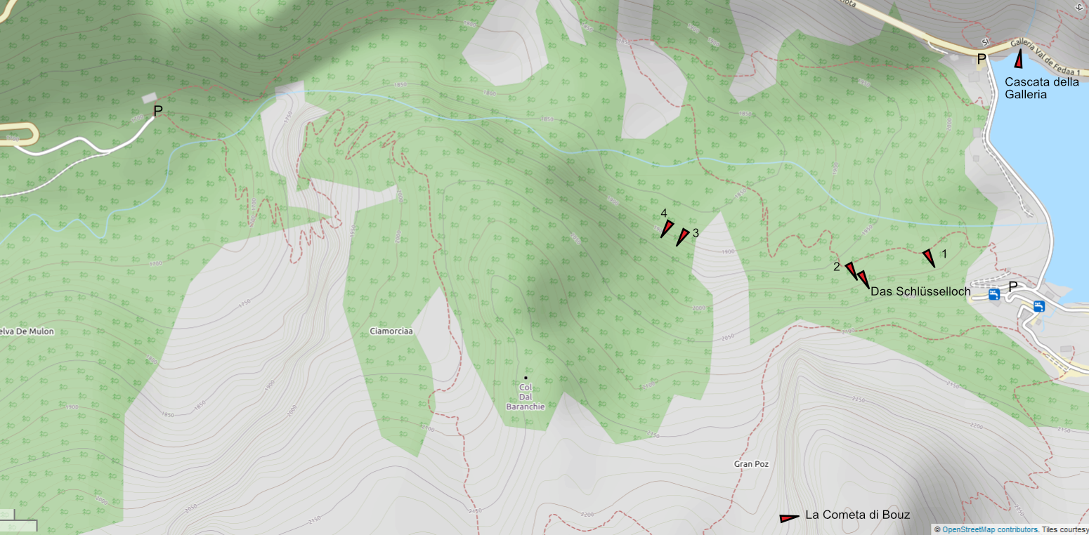
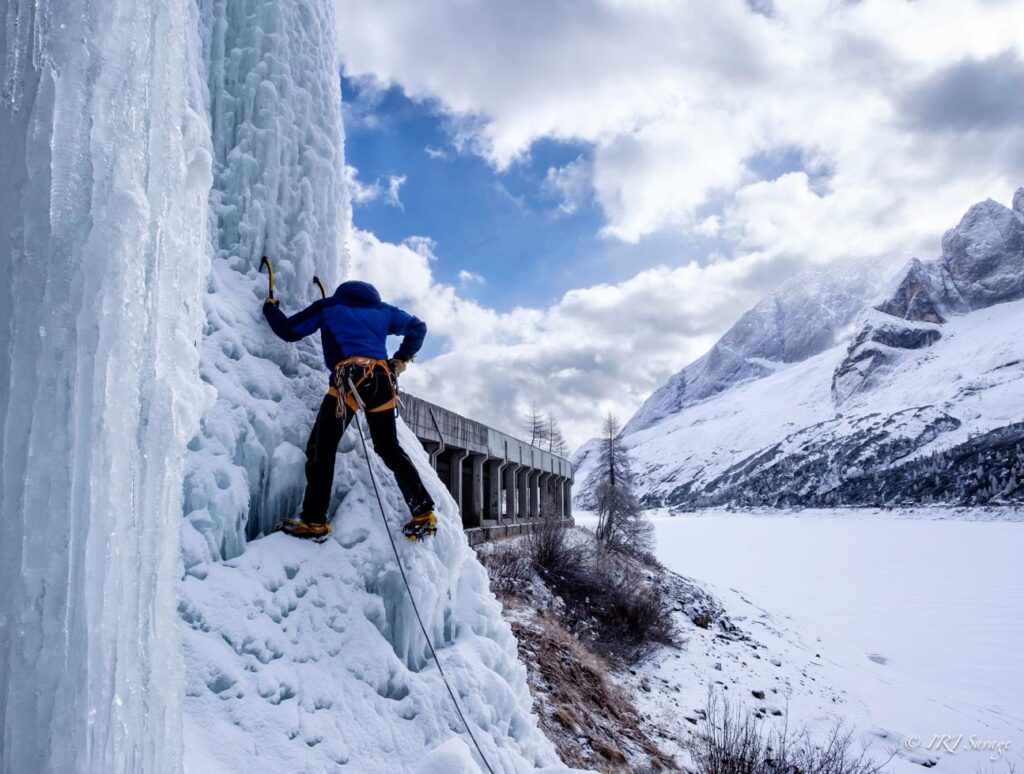
Cascata della Galleria 10m WI2+
Cascata della Galleria is easily accessed from Rifugio Castiglioni – just part by the hut and walk 10m! First climbed on a whim, and almost too ridiculous to include, it’s actually kind of fun and you can be on it in approximately 30 seconds, it will take all of a few minutes to climb and you’re back at the car in no time at all! The ice fall is actually a gutter from the roof of the gallery and forms a pillar in quite a stunning spot.
Above there is an icefall which occasionally forms, I have no idea whether this has been climbed. If you know, please write to me and I can include it here.
Below the dam
Access to routes 1, Das Schlusselloch and 2 is relatively easy, from the southern end of the dam. Drive over the dam and immediately on your right you will see a souvenir shop and bar, called Bar Diga. Park in the carpark at the back of the bar and then walk to the end of the carpark where you will find a marked path that descends into the valley, quite steeply to begin with. After about 5-10 minutes depending on conditions you will see the first icefalls on the left. If you continue beneath the cliff you will reach a deep twin gully which is the location of das Schlussellock and 2.
If you have names for the routes, and a first ascensionist, please let me know!
Route 1 WI 3+, 40m
This is the first route on the left and climbs a wide slab at its left most extreme. Start by climbing from a small cave directly up a short steep wall onto the slab, the ice may be quite tin here. Here you can either continue directly up steep steps, or trend slightly right but the smooth ice slab to a final wall. We climbed it in two pitches, but it should be possible to climb it in one given the right conditions and enough screws. Finish at a pair of trees beneath a rock wall, to the left of a higher set of falls which form a curtain of ice.
There are a number of other features to the right which we feel almost certainly have been climbed – please let me know if you have information.
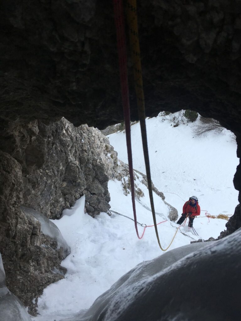
Durch Den Schlusselloch WI4/M, 100m
From Route 1 descend another 150m to find a deep twin gully which climbs towards an obvious streak of left trending ice. This route follows the first gully, on the left.
1: WI2 Climb the narrow gully easily to a boulder choke where you can belay
2: After climbing the boulder (may not exist after snow) you reach a wide open bowl, climb left to a thin streak of ice below a small tunnel in the rock.
3: AI4/M4 Climb to the tunnel, take off your sack and then drag yourself through it, pulling your sack behind you. Then climb the very thin ice diagonally leftwards, eventually reaching a tree
4: Either descend from here or continue up snow for 50m to reach the aquaduct which crosses the mountainside. You can use the aquaduct to return to the dam.
Route 2 - information needed
The original objective when climbing Das Schlusselloch was to see if we could connect to the obvious ice smear. At the time, the ice from this had not connected to the ground, but recently I went back and saw that it should be possible with good late season conditions to climb a fine look line which would give a fine route, with a steep first pitch, maybe WI4+? If you have climbed it please let me know!
Access to routes 3&4 is best from Pian Trevisian, where you can park at a haripin in the road to Canazei or at Albergo Villeta Maria and walk into the valley. When there is snow, even after a warm spell it is likely that you will need snowshoes or skis as the snow stays cold and powdery for a long time here. When coming from Pian Trevisian, follow the path and after 1.5km, cross the valley to the southern side. In amongst the trees there are two parallel cascades, some 50m high.
Route 3 - information needed
The cascade which we did not climb is a clear objective and starts from a terrace. It seems there would be substantial volumes of ice.
Route 4a and b - Information needed WI 3+
The cascade to the right can be taken two different ways, on the left or the right. Start by a large open cave and climb an initial short steepening, either going left up a continuously steep cascade in one pitch to the top, or go to the right of a rock, then rejoin the fall higher up for a final steep section. This second line is what we climbed, finishing at a tree where we found a cord and Maillion and seemed to be easier than the lefthand line, which I would expect to be WI4/+.
Gran Poz
The Gran Poz is a large outcrop which hangs above the dam and is quite obvious and slabby. It is home to some easy rock slab climbs and some other lines which we know exist but have no information about. Again, if you know what these routes to the right are, please get in touch as we would be interested to publish a guide here!
Gran Poz seems to have several ice lines, but only one has been recorded in Ghiaccio Verticale:
La Cometa di Bous 55m WI5***
La Cometa di Bous has quite a long approach across a steep terrace. Take care when crossing as it is easy to slip here and when conditions are firm underfoot, it could end in a fatal slip, as has happened in the past. Park in the upper car park by the lift to Pian di Fiaconi. Walk up 20 yards and then head right across the ski piste to find a path through the trees and scrub. This leads up and west to the aforementioned terrace which steepens and narrows the further you go across until you are directly beneath the Gran Poz. Follow the cliff round for several hundred metres into am open bowl beneath Marmolada and you will see the large icefall of Cometa di Boes on the left. 1.5hrs Climb the icefall start on the left, slowly working up to finish on the right.